
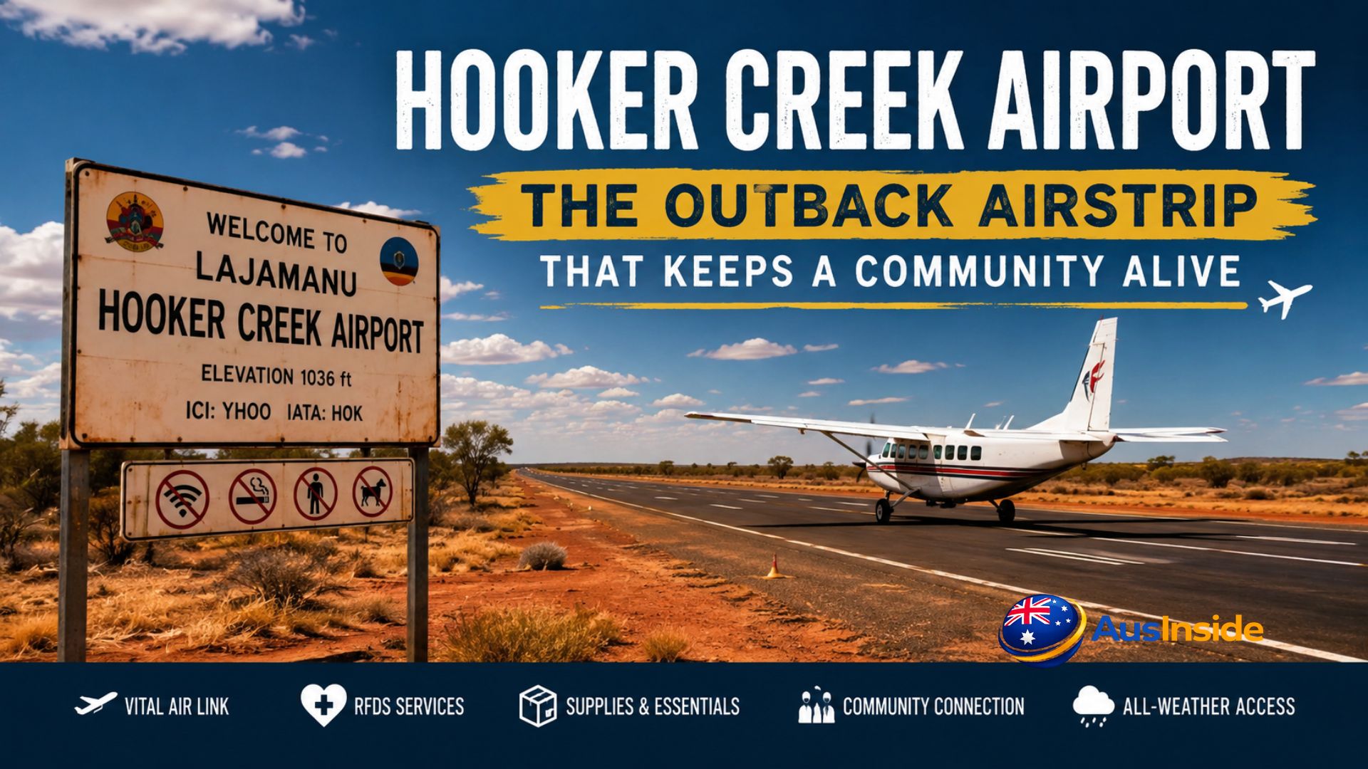
Most airports exist to make travel more convenient. Hooker Creek Airport exists to make survival possible.
Located in Lajamanu — a remote Warlpiri Aboriginal community sitting on the northern edge of the Tanami Desert in Australia’s Northern Territory — this small sealed airstrip is one of the most quietly important pieces of infrastructure in the country. It has no commercial terminal. No scheduled flights you can book online. No Qantas or Jetstar. Just a bitumen runway, a handful of operators, and a community of roughly 655 people whose connection to the outside world runs almost entirely through it, especially when the wet season turns the surrounding roads into rivers.
Understanding Hooker Creek Airport means understanding where it is and what the alternative looks like. Katherine, the nearest regional town, sits 560 kilometres away. Darwin is 890 kilometres north. The single road in — the Lajamanu Road connecting to the Buntine Highway — is unsealed for most of its length, passes through unfenced cattle country shared with feral horses, donkeys, camels, and kangaroos, and floods completely for months every wet season. When the road closes, the airport isn’t a backup. It’s the only option.
That’s not dramatic framing. It’s operational reality. And it shapes everything about how this airport functions, who uses it, and why it matters far beyond its modest footprint.
Have A Look On It: Aramac Airport
- Quick Reference: Hooker Creek Airport at a Glance
- Why This Airport Has Two Names
- The Community Behind the Airstrip
- The Wet Season Problem and Why a Sealed Runway Changes Everything
- Who Flies Here and Why
- The Technical Side: What Pilots Need to Know
- The History You Won't Find in Aviation Databases
- Getting to Lajamanu: What You Actually Need to Know
- The Bigger Picture: What You Don’t Know
- Final Thoughts
- Frequently Asked Questions
Quick Reference: Hooker Creek Airport at a Glance
| Detail | Information |
| IATA Code | HOK |
| ICAO Code | YHOO |
| Also Known As | Hooker Creek Aerodrome / Lajamanu Airport |
| Location | Lajamanu, Northern Territory, Australia |
| Coordinates | S18°19.70′ / E130°38.80′ |
| Elevation | ~1,036–1,089 ft above mean sea level |
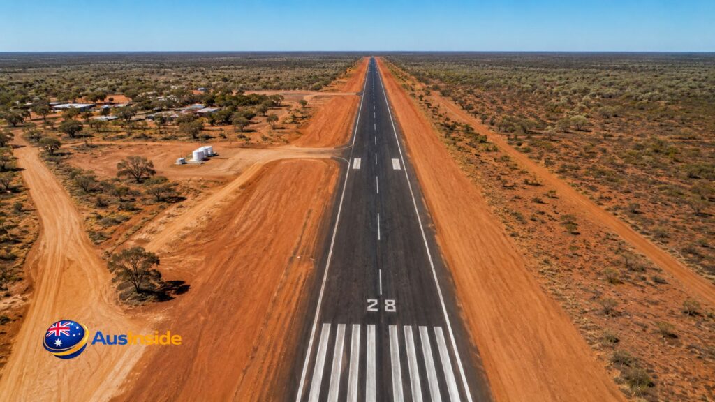
| Runway | 10/28, sealed bitumen |
| Radio Frequencies | CTAF 126.7 MHz / 134.2 MHz |
| Operators | Chartair (RASS), RFDS, RAAF |
| Annual Rainfall | ~571 mm (mostly wet season) |
Why This Airport Has Two Names
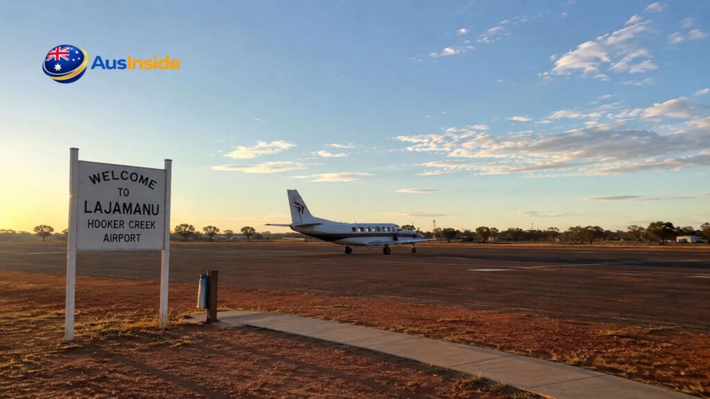
Search for HOK online and you’ll see it listed variously as Hooker Creek Airport, Hooker Creek Aerodrome, and Lajamanu Airport. All three refer to the same sealed strip. The confusion comes from the community’s own history.
The location was originally named Hooker Creek after a permanent waterhole nearby called Catfish. In 1949, the Australian federal government established an Aboriginal settlement here — and it stayed “Hooker Creek” in official records for decades. The aviation codes YHOO and HOK were registered under that name and have never been updated.
But the community itself moved on. In the 1980s, the settlement was formally renamed Lajamanu, derived from a Gurindji place name. The Lajamanu Council, established in 1980, was actually the first Community Government Council formed anywhere in the Northern Territory. The name change mattered deeply to residents — it was a step away from colonial administration and toward self-definition. The airport codes, however, are assigned by international aviation bodies and rarely change once set.
So the airstrip carries its colonial name quietly in the global aviation database while the community it serves has moved forward. That small detail, easily overlooked by anyone just looking up an IATA code, carries a lot of history.
Google Map Location
The Community Behind the Airstrip
Lajamanu is a strongly traditional Warlpiri community. Of its approximately 655 residents, over 92 percent are Aboriginal Australians — primarily Warlpiri people, though the land itself is traditionally Gurindji country. The two communities have a formal relationship around this: in the late 1970s, the Gurindji people conducted ceremonies in which they handed custodial responsibilities for the Lajamanu area to the Warlpiri Patrick family, a unique cross-cultural handover that is still honoured today.
The community is dry — no alcohol permitted — and governed by both the Central Desert Regional Council and the Kurdiji group, a body of senior men and women whose name in Warlpiri means “shield.” They work to maintain both traditional Aboriginal law and engagement with the Australian legal system. It is not a tourist destination, not a pit stop, not a gateway to anywhere else. It is a self-contained community with its own school (preschool through Year 12), health centre with 24-hour emergency care, community store, and the Warnayaka Art Gallery — a Warlpiri-run art centre whose artists have been finalists in the Telstra National Aboriginal and Torres Strait Islander Art Awards multiple times.
Non-Indigenous people present at any given time are almost entirely service providers: nurses, teachers, police, government workers. They all rotate in and out through the airstrip. That constant professional movement — plus emergency medical evacuations, medicines, fresh food, mail, and urgent supplies — is what the airport carries on its runway every week.
The Wet Season Problem and Why a Sealed Runway Changes Everything
Here’s something most airport articles never explain properly: the difference between a sealed and an unsealed remote airstrip is not cosmetic. It’s the difference between a community staying connected through a wet season or being completely isolated for months.
The Northern Territory’s wet season runs roughly from November to April. During this period, Lajamanu receives most of its annual 571 millimetres of rainfall in intense bursts. The unsealed roads around the community — including the Lajamanu Road to the Buntine Highway — become impassable for heavy vehicles and are frequently cut entirely by flooding. In 2007, 2023, and 2024, floodwaters reached the southern edge of the community itself.
An unsealed dirt airstrip floods too. It develops soft patches, washouts, and surface ruts that make landing dangerous or impossible for even a light aircraft. When that happens to a community’s airstrip, the RFDS may not be able to land in an emergency. The mail plane can’t get in with medicines. Fresh food stops arriving. Sick patients can’t be evacuated.
The sealed bitumen runway at Hooker Creek Airport drains far better and maintains its structural integrity through the wet. It means the RFDS can land a medical evacuation flight at 2 am during monsoonal rain if it needs to. It means the Chartair mail plane keeps running on its weekly schedule regardless of what’s happening on the road. That sealed surface — something that might barely rate a mention in a standard airport listing — is the engineering detail that makes year-round connectivity possible.
Who Flies Here and Why
Chartair and the Government Mail Plane
The primary regular operator at Hooker Creek Airport is Chartair, a Darwin-based general aviation company with over 45 years operating across the Territory. Chartair runs the federal government’s Remote Air Services Subsidy (RASS) Scheme across the NT and Western Australia — a program most Australians have never heard of but which is, quietly, one of the more important pieces of remote infrastructure policy in the country.
The RASS Scheme subsidises weekly air transport to up to 276 remote communities across Queensland, NT, South Australia, WA, and Tasmania. It covers passengers, Australia Post mail, medicines, educational materials, fresh food, and other urgent cargo. The subsidy is paid directly to the operator — in this case Chartair — so the flights happen whether they’re commercially viable or not. Without it, communities like Lajamanu simply wouldn’t have regular air access.
Locals call it the “mail plane,” which tells you something about its role. It’s not a commercial product. Seats on RASS flights are restricted to community members and service providers only — not available for tourism or casual travel. A teacher flying in for a new school term, a nurse arriving for a rotation, a government official attending a community meeting, a Lajamanu resident travelling to Katherine for a medical appointment — these are the passengers. Every week, without fail.
The Royal Flying Doctor Service
The RFDS is present at virtually every remote NT airstrip, and Hooker Creek Airport is no exception. With the nearest hospital in Katherine being 560 kilometres away and Darwin nearly 900 kilometres north, the RFDS is the emergency medical system for Lajamanu. Serious cases — trauma, cardiac events, complicated births — are evacuated by CareFlight or RFDS aircraft to Katherine or Darwin.
The RFDS fleet, primarily Pilatus PC-12 turboprops, is specifically designed for remote short-field operations. These aircraft can land on runways far shorter and rougher than what major airports offer, carry full in-flight medical capability, and operate at night. The sealed runway at Hooker Creek means RFDS pilots can land with confidence in wet conditions when an unsealed strip would be unsafe. For a community with no specialist medical care on-site, that assurance is not a small thing.
The RAAF
The Royal Australian Air Force uses Hooker Creek Airport periodically, as it does many remote NT airstrips. RAAF Base Tindal, near Katherine, is the major military installation in the region. Remote community airstrips across northern Australia form part of a broader network used for training, logistical support, and contingency operations. Northern Australia is a significant strategic focus for the RAAF given the distances involved and the sparse infrastructure across the region.
The Technical Side: What Pilots Need to Know
Runway 10/28 runs roughly east-west to align with the prevailing winds typical of this part of the Territory. It is a non-controlled aerodrome — no tower, no ATC — which means pilots manage their own sequencing using the Common Traffic Advisory Frequency (CTAF) at 126.7 MHz.
The elevation of approximately 1,000 feet above sea level matters more than it might seem. In aviation, “density altitude” — the effective altitude the aircraft performs at, accounting for temperature and actual elevation — determines how much runway you need. On a standard 40-degree Celsius day in the Territory’s interior, a light twin-engine aircraft at this field will require noticeably more runway than the same aircraft at sea level on a cool day. Charter pilots flying into Lajamanu calculate this every single time, adjusting fuel loads and passenger weights accordingly. Operating at or near maximum gross weight on a hot day at elevation is precisely how accidents happen at remote strips.
There’s also the wildlife factor. The Lajamanu Local Emergency Plan explicitly notes feral horses, donkeys, camels, and kangaroos as road hazards in the area. These animals don’t respect runways either. RFDS protocols require pilots to confirm runways are clear before landing at remote strips — including conducting an aerial inspection pass if they can’t reach someone on the ground. A kangaroo or camel on a runway at night during a medical evacuation is not a theoretical risk.
The History You Won’t Find in Aviation Databases
What makes Hooker Creek Airport genuinely unusual has nothing to do with its ICAO code or runway length. It’s the story of how the community it serves came to exist.
In 1948, the Australian government’s Native Affairs Branch decided to establish a new settlement at this permanent waterhole, 600 kilometres north of the Warlpiri community at Yuendumu. The stated reason was overcrowding and drought at Yuendumu. The method was trucking people to an unfamiliar location on land that wasn’t their traditional country and expecting them to stay.
They didn’t stay. The Warlpiri people walked back to Yuendumu. Then they were rounded up and trucked back to Hooker Creek. They walked back again. This happened three times — hundreds of kilometres on foot through desert terrain, driven by the pull of their Dreaming sites, their kin, their country. By the third attempt, children had been born at Hooker Creek. Ties to the new place had formed. People stayed.
This is not ancient history. The grandparents and great-grandparents of people living in Lajamanu today walked those roads. The community’s relationship with government authority — including government-operated infrastructure like the airport — is shaped by that memory. When the federal RASS mail plane lands each week, it is landing in a place whose very existence reflects decades of policy imposition that the residents have spent generations reclaiming on their own terms.
Getting to Lajamanu: What You Actually Need to Know
If you’re planning to visit Lajamanu — researcher, journalist, government worker, invited guest — there are several things the standard aviation guides won’t tell you.
You need a permit. Lajamanu is Aboriginal land under the Northern Territory’s permit system, administered by the Central Land Council. You must obtain approval before entering, regardless of whether you’re arriving by road or air. This is not a formality; it is law, and it applies to everyone.
RASS flights are not for tourists. Chartair’s mail plane seats are strictly for community members and approved service providers. If you need to get to Lajamanu for a legitimate purpose, contact Chartair directly about charter options, or arrange travel through whatever government or organisation you’re working with.
Road access is dry-season only for most visitors. From roughly May to October, the Lajamanu Road is passable with a capable 4WD. The route from Katherine runs south on the Victoria Highway, then 180 kilometres west on the sealed Buntine Highway, then approximately 115 kilometres on unsealed road south from Kalkarindji. Allow a full day. During the wet season, that road is frequently impassable and aviation is the only reliable option.
Accommodation is not a standard tourist product. There is no hotel or guesthouse in Lajamanu. Service providers and visiting staff typically use community-provided accommodation, arranged in advance through the relevant organisation. Do not arrive expecting to find somewhere to stay.
The Bigger Picture: What You Don’t Know
Every article about Hooker Creek Airport lists the IATA code, mentions it’s in the NT, and stops there. Here’s what that misses.
The airport is part of a federal network that is genuinely critical to Australia’s remote population. The RASS scheme serves up to 276 communities. The Australian Government announced $50 million in additional Remote Airstrip Upgrade funding in the 2024-25 Budget — because the infrastructure degrading at these strips has direct consequences for human lives, not for passenger inconvenience. Round 11 of that program, which closed for applications in December 2024, funded 42 projects announced in October 2025.
The mean annual rainfall at Lajamanu Airport is 571 millimetres — not negligible, and falling mostly during the wet season when roads are already vulnerable. The health centre serving the community has nine consulting rooms, six treatment rooms, and one emergency room. Serious cases requiring hospital-level care — anything that can’t be stabilised locally — leave through the airstrip. There are no aged care facilities in Lajamanu. Elderly residents who need specialist care travel by air to Katherine or Darwin.
And then there’s this: in February 2010 and again in February 2023, hundreds of live spangled perch rained down on Lajamanu. The fish are real. The scientific explanation is that these small freshwater fish have exceptional overland dispersal ability during heavy rain events and can end up scattered across ground that’s rapidly flooded, leading to reports that they fell from the sky. The story went international both times. It says something about the intensity of the wet season in this part of Australia — and it’s the kind of local detail that makes Lajamanu genuinely unlike anywhere else.
Don’t Forget To Read It: Katherine High School
Final Thoughts
Hooker Creek Airport is small enough to miss on a map. But strip it away and a community of 655 people loses their emergency medical lifeline, their weekly food and medicine supply, and their connection to the wider country — especially for the four to five months each year when the road is impassable.
The sealed runway isn’t a luxury upgrade. It’s the feature that makes year-round operations possible. The RASS scheme isn’t a subsidy for inconvenience. It’s the system that makes remote Aboriginal communities viable. The RFDS presence isn’t a nice-to-have. It’s the emergency room that Katherine Hospital is too far away to provide.
Hooker Creek Airport is HOK on a flight tracker and YHOO in a pilot’s approach plate. But in Lajamanu, it’s the strip that planes land on when someone is sick and the road is flooded and there is no other way.
Frequently Asked Questions
What is the IATA code for Hooker Creek Airport?
HOK. The ICAO code — used in flight planning and by air traffic control — is YHOO. You’ll also see it listed as Lajamanu Airport in some databases, referring to the same airstrip.
Can I book a commercial flight to Hooker Creek Airport (HOK)?
No commercial airline services operate to Lajamanu. The primary scheduled service is Chartair’s RASS mail plane, which is restricted to community members and approved service providers. Private charter flights can be arranged through NT-based operators like Chartair, but Lajamanu is a permitted Aboriginal community — you’ll need Central Land Council approval to enter regardless of how you travel.
Why is it called Hooker Creek Airport if the town is Lajamanu?
The airport was registered under its original colonial-era name, Hooker Creek, before the community was renamed Lajamanu in the 1980s. IATA and ICAO codes, once assigned, are rarely updated. The community itself has moved on from the name; the aviation database hasn’t.
What airlines or operators fly to Hooker Creek Airport?
Chartair is the main private operator, running RASS-subsidised freight and passenger services. The Royal Flying Doctor Service uses the strip for medical evacuations and outreach clinics. The Royal Australian Air Force also uses it periodically. No commercial airlines fly here.
Is the airstrip operational during the wet season?
Yes. The sealed bitumen runway is one of the key reasons Hooker Creek Airport can operate year-round. Unsealed dirt strips in the region become unusable in wet conditions; the sealed surface at Hooker Creek drains better and maintains its integrity, allowing RFDS and supply flights to continue when roads are impassable.
How long is the runway at Hooker Creek Airport?
Runway 10/28 is the single runway. Exact published length varies slightly by source, but it accommodates the light turboprop and piston aircraft that serve remote NT communities, including RFDS Pilatus PC-12s and various charter aircraft. The elevation (~1,000 ft AMSL) and high ambient temperatures require pilots to account for reduced performance on hot days.
Do you need a permit to visit Lajamanu?
Yes. Lajamanu is located on Aboriginal land and requires an entry permit issued by the Central Land Council. This applies to everyone — researchers, journalists, tourists, contractors — regardless of whether they arrive by road or air. Visiting without a permit is an offence under Northern Territory law.