

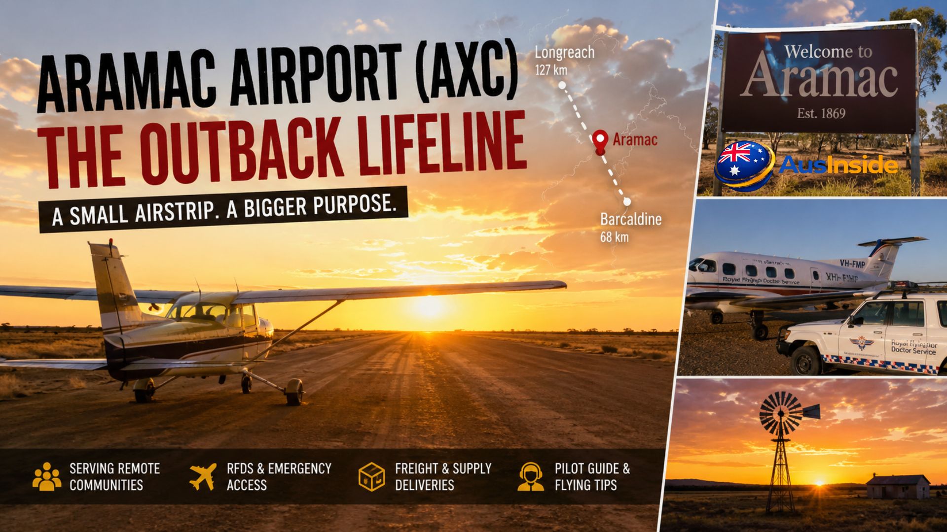
There’s a strip of gravel in Central Queensland, one kilometre from a town of roughly 370 people, that holds more practical importance than most people would ever guess just looking at it. No terminal building. No commercial flights. No coffee shop. Just a runway designated 11/29, a pair of aviation codes recognised worldwide, and a community that depends on it in ways that become very clear when you understand where Aramac actually sits on the map.
Aramac Airport — IATA code AXC, ICAO code YAMC — serves the town of Aramac, located approximately 1,280 kilometres by road from Brisbane, 68 kilometres north of Barcaldine, and 127 kilometres north-east of Longreach. These numbers don’t quite capture the isolation. Central Queensland’s outback is flat, hot, prone to flooding, and characterised by the kind of distance that makes even a sealed road feel unreliable in wet season. For the graziers, families, and suppliers who use this airstrip, it’s not supplementary infrastructure. It’s often the only option that makes sense.
This is a thorough look at Aramac Airport — what it is, how it works, who uses it, what pilots need to know, and why a tiny unlicensed aerodrome in one of Australia’s most remote corners deserves genuine attention.
Have A Look On It: Tallaringa Conservation Park
- Quick Overview
- Where Aramac Sits — and Why Location Changes Everything
- The Airport Itself: Technical Facts Worth Understanding
- Who Actually Uses Aramac Airport — and For What
- Barcaldine Regional Council and the Network It Manages
- What Pilots Need to Know Before Flying Into YAMC
- What Competitors and General Sources Get Wrong About This Airport
- The Broader Picture: Remote Aerodromes and Outback Connectivity
- Key Facts Before You Go
- FAQs
Quick Overview
| Detail | Information |
| Full Name | Aramac Airport |
| IATA Code | AXC |
| ICAO Code | YAMC |
| Airport Type | Public, Unlicensed |
| Operator | Barcaldine Regional Council |
| Location | 1 km from Aramac, Central Queensland, Australia |
| Coordinates | 22°57′28.4″S 145°14′58.6″E |
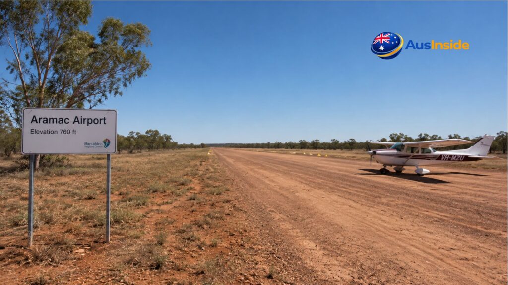
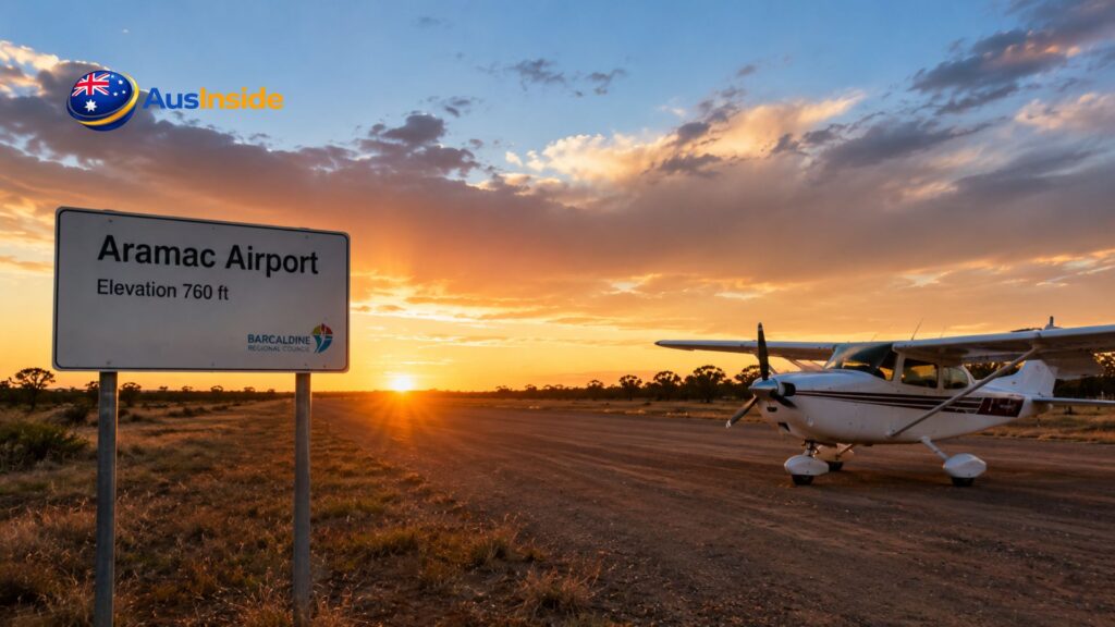
| Elevation AMSL | 760 ft (232 m) |
| Runway Designation | 11/29 (single runway) |
| Magnetic Variation | 8°E |
| Flight Information Region | Brisbane FIR |
| METAR Published | No — nearest weather station ~480 km away (Hamilton Island) |
| Fuel Available | No |
| Scheduled Services | None |
| Timezone | UTC +10 (AEST, no daylight saving) |
| Nearest Major Airport | Longreach Airport (~110 km west) |
Where Aramac Sits — and Why Location Changes Everything
Aramac is one of the oldest towns in Central Queensland. The name itself traces back to 1859, when explorer William Landsborough came through the region, named a local creek after former Queensland Premier Robert Ramsay Mackenzie (carving the initials “R.R. Mac” into a tree), and the phonetic echo of that inscription eventually became the town’s identity. Formal settlement followed — a bark-hut store in 1869, a surveyed town by 1875, and by the late 1800s a reasonably active community built around the region’s primary industry: large-scale grazing.
That industry still defines the area today. The land around Aramac is Mitchell grass plains — excellent country for beef cattle — and the surrounding stations are enormous. Queensland holds the largest beef cattle herd in Australia, with over 13.5 million head as of 2025, and the central west region around Aramac and Longreach contributes substantially to that figure. When a station runs across tens of thousands of hectares, its managers and workers aren’t always close to a town. And when they need to move quickly — for a medical emergency, for business in Longreach or Brisbane, for time-sensitive supplies — the road is the slow option.
That’s where aviation comes in. Not just as convenience. As a functional necessity.
The town had a tramway once — a narrow-gauge light railway that ran from 1913 until it closed on 31 December 1975. The Aramac Tramway Museum, now a heritage-listed site on Boundary Street, preserves what remains of that era. When the tramway shut down, the region lost its most reliable surface freight link. Aviation and roads have filled the gap since, with aviation carrying the weight when roads become impassable during wet season flooding.
Google Map View
The Airport Itself: Technical Facts Worth Understanding
Aramac Airport is classified as a public, unlicensed aerodrome under Australian aviation regulations. This is a designation that causes some confusion, so it’s worth being precise about what it actually means.
In Australia, the Civil Aviation Safety Authority (CASA) distinguishes between licensed aerodromes — those certified to meet specific infrastructure, safety, and operational standards — and unlicensed ones. Unlicensed doesn’t mean unofficial or unrecognised. YAMC carries both an ICAO code and an IATA code, appears in the official Airservices Australia En Route Supplement Australia (ERSA), and falls within the Brisbane Flight Information Region. What it means is that commercial air transport operations face additional considerations, and certain infrastructure requirements that licensed aerodromes must meet are not mandatory here.
The single runway is designated 11/29, which refers to magnetic headings of roughly 110° (east-southeast) and 290° (west-northwest). The aerodrome sits at 760 feet above mean sea level — about 232 metres. Magnetic variation at the field is 8° East. The coordinates place it at 22°57′28.4″S, 145°14′58.6″E, and the entire aerodrome sits approximately one kilometre from the town centre.
What the Field Does Not Have
- Published METAR weather observations
- Fuel (no avgas, no Jet-A1)
- Air traffic control
- Lighting systems (no night operations capability noted in public records)
- Terminal facilities
- Scheduled airline services
The nearest published weather station is Hamilton Island Airport — roughly 480 kilometres away. That’s a detail that matters enormously for flight planning, which we’ll cover shortly.
Who Actually Uses Aramac Airport — and For What
This is where the real story lives, because the airport’s value isn’t measured in passenger throughput. It’s measured in what becomes possible because of it.
Station owners and local residents use it to reach Longreach, the nearest regional hub with scheduled QantasLink services to Brisbane. Rather than a four-hour return drive on unsealed roads, a light aircraft flight connects Aramac to Longreach in under an hour. From Longreach, the national aviation network becomes accessible.
Charter operators based in Longreach and Muttaburra can be engaged to fly into Aramac when needed. This gives the community flexible access to aviation even without locally based aircraft. The arrangement is informal but functional — the kind of practical system that remote outback communities have developed over decades because formal infrastructure rarely appears unless there’s a commercial case for it.
Freight and supply operations use the strip to bring in time-sensitive or high-value goods. Agricultural chemicals, veterinary supplies, specialist equipment for machinery breakdowns during mustering season — the outback reality is that waiting for a road delivery can mean the difference between a functioning operation and a costly delay. Light aircraft have served this freight function in remote Queensland since the mid-twentieth century.
Emergency medical services represent the airport’s most critical role. The Royal Flying Doctor Service has been delivering aeromedical care to remote Australians since 1928, founded in Cloncurry, Queensland, as the Australian Inland Mission Aerial Medical Service. Today the RFDS assists more than 330,000 Queenslanders each year — roughly one person every two minutes — and its operations depend entirely on a network of small, accessible airstrips spread across the state. The RFDS Queensland section provides 24-hour aeromedical retrieval, dental services, mental health support, and primary health clinics. None of that reaches Aramac without a serviceable airstrip.
The nearest hospital with serious emergency capability from Aramac is in Longreach. By road, in normal conditions, that’s around two hours. In a genuine medical emergency — a farm accident, a cardiac event, a premature birth on a remote property — two hours on a rough road is not always survivable. A RFDS aircraft using a strip like YAMC changes that equation fundamentally.
Barcaldine Regional Council and the Network It Manages
Aramac Airport isn’t an isolated piece of infrastructure — it’s part of a deliberate network. Barcaldine Regional Council, which came into existence in 2008 through the amalgamation of the former Shires of Aramac, Barcaldine, and Jericho, operates multiple aerodromes across the region. These include:
- Barcaldine Airport (BCI/YBAR) — the network’s most commercially active facility, with QantasLink scheduled services to Brisbane and Longreach
- Aramac Airport (AXC/YAMC) — general aviation, charter, freight, emergency services
- Muttaburra Airport (UTB/YMTB) — similar function, ~90 km north-west of Aramac
- Alpha Airport (ABH/YAPH) — serving the Alpha township to the south-east, also RFDS-serviced
The council maintains all of these. That’s a significant responsibility for a local government serving a relatively small ratepayer base across thousands of square kilometres of semi-arid Queensland. The economic justification for this network isn’t hard to make — emergency access alone would carry the argument — but it’s worth recognising that maintaining a functional aerodrome involves more than a graded runway. Wildlife management, surface condition monitoring, signage, and ensuring that NOTAMs are issued when conditions change are all ongoing operational requirements.
What Pilots Need to Know Before Flying Into YAMC
Flying into a remote, unlicensed outback aerodrome without careful preparation is the kind of decision that experienced pilots look back on with relief that nothing went wrong. Here is what matters.
Weather planning is entirely your responsibility. There is no METAR for YAMC. The nearest reporting station is Hamilton Island, 480 kilometres to the north-east — a different weather regime entirely in many conditions. Pilots must build their weather picture from area forecasts, the SIGMET and AIRMET system within the Brisbane FIR, satellite imagery, and whatever local knowledge they can gather. In summer, Central Queensland can produce violent afternoon thunderstorms with very little warning. These are not something to be caught beneath in light aircraft.
Fuel is not available on-site. This is non-negotiable in terms of planning. Every flight into Aramac needs to carry sufficient fuel for the destination leg plus legal reserves plus a realistic alternate — most likely Longreach or Barcaldine, both of which have fuel. Running lean on reserves into a remote aerodrome with no fuel is how stranded-aircraft situations happen.
Density altitude in summer is a real performance factor. At 760 feet physical elevation, the aerodrome doesn’t sound particularly challenging on paper. But in Central Queensland summer, with air temperatures regularly exceeding 40°C, density altitude can exceed 3,000 feet on a hot afternoon. Aircraft performance — particularly climb performance after takeoff — degrades significantly. Runway surface penalties apply on grass or gravel (which can add 20-40% to required ground roll compared to sealed surfaces). Pilots accustomed to sea-level performance need to consult their POH charts honestly.
Kangaroos and other wildlife use the runway. This is standard outback Queensland behaviour — kangaroos, emus, and various other animals treat airstrips as open grassland, which they essentially are. A low approach circuit before landing to check for animals isn’t excessive caution; it’s basic airmanship in this environment. Dawn and dusk are the highest-risk periods.
Check the current ERSA entry and NOTAMs. The FAC YAMC entry in the Airservices Australia En Route Supplement Australia (effective 19 March 2026 at the time of writing) is the authoritative reference. Surface condition, any temporary restrictions, and other relevant information will be here. Because Aramac is remote, surface deterioration after rainfall may not be reported as promptly as at busier fields — when in doubt, contact the operator (Barcaldine Regional Council) directly.
No ATC, CTAF procedures apply. Pilots self-announce on the Common Traffic Advisory Frequency for the area. Standard non-towered aerodrome procedures under Australian regulations and good airmanship practice both apply.
What Competitors and General Sources Get Wrong About This Airport
Most information available about Aramac Airport online either repeats basic data (coordinates, codes, runway designation) or treats it as a curiosity — a tiny remote strip notable mainly for being small. This misses several important realities.
The first is that “unlicensed” and “insignificant” are not the same thing. YAMC appears in official Airservices Australia publications. It carries internationally recognised coding. It has real operational users who depend on it for genuine, often urgent purposes. The licensing framework in Australia recognises that remote community aerodromes serve vital functions that cannot be commercially justified but must be maintained regardless.
The second is that the absence of scheduled services does not indicate declining importance. If anything, the flexibility of the charter and general aviation model suits remote outback communities better than scheduled services would. A scheduled airline service to Aramac would require demand sufficient to justify fixed departure times, aircraft positioning, and terminal infrastructure. The actual demand is sporadic but high-value — which suits on-demand charter and private operations far better.
The third is that the nearest weather station being 480 kilometres away is not a trivia fact — it’s a safety-critical operational reality that distinguishes flying into YAMC from flying into almost any other public aerodrome in Australia. That detail deserves prominent attention in any serious treatment of this airport.
The Broader Picture: Remote Aerodromes and Outback Connectivity
Australia’s interior has always demanded creative infrastructure solutions. The Royal Flying Doctor Service itself was founded because road distances made conventional medical access impossible for remote communities — a problem that existed in Aramac’s region as much as anywhere else. The RFDS now assists people every two minutes across Queensland alone, operates a fleet of 87 aircraft nationally, and has been doing this for almost a century. Every one of those aircraft needs somewhere to land.
The network of council-managed aerodromes in Central Queensland — Aramac, Alpha, Muttaburra, Barcaldine — collectively forms an aviation safety net for a region where the alternative to flying is often hours on unsealed roads that may be cut off by flood. When the Barcaldine-Aramac Road is under water after heavy rain — and in this part of Queensland, that does happen — Aramac Airport’s runway can be the only connection the town has with the outside world.
That’s the thing about infrastructure in remote Australia. Its importance is not proportional to how busy it looks.
Don’t Forget To Read It: Mount Clarence Station
Key Facts Before You Go
For pilots planning to operate into YAMC: consult the current ERSA (FAC YAMC), check NOTAMs, obtain a weather briefing from NAIPS or an equivalent service, plan fuel conservatively with Longreach or Barcaldine as your realistic alternate, carry a full satellite communicator, and be genuinely prepared for the possibility that conditions on arrival are different from what you planned for. If you’re carrying passengers unfamiliar with remote operations, brief them. Remote outback flying is not inherently dangerous but it does not forgive sloppy preparation.
For visitors to the Aramac area: the town itself is historically rich. The Aramac Tramway Museum preserves the heritage of the 1913 light railway and the early settlement era. The Harry Redford Interpretive Centre tells the story of one of the outback’s most colourful legends. Lake Dunn and the surrounding sculpture trail are genuinely distinctive outback experiences. Accommodation in Aramac is limited, so book ahead.
For anyone interested in remote infrastructure and how outback Australia actually works: Aramac Airport is a good case study. Small, unglamorous, essential.
FAQs
Are there any commercial flights from Aramac Airport?
No scheduled commercial airline services operate from Aramac Airport. The nearest commercial flights are at Longreach Airport (approximately 110 km west), where QantasLink operates services to Brisbane. Travellers from Aramac typically charter aircraft to Longreach, or arrange charter pick-up directly from YAMC via operators based at Longreach or Muttaburra.
Is fuel available at Aramac Airport (AXC)?
No. Neither avgas nor Jet-A1 is available at YAMC. This is a critical planning point for any pilot flying into the aerodrome — fuel must be carried for the inbound leg, legal reserves, and a realistic diversion to an alternate (Longreach Airport is the most practical option).
What does “unlicensed aerodrome” mean in Australia?
It means the aerodrome is not certified by CASA to the same standard required for commercial air transport operations. It does not mean unrecognised or informal — YAMC has official IATA and ICAO codes and appears in the Airservices Australia ERSA. Pilots operating light aircraft can use it, but should check current ERSA entries and relevant NOTAMs, as certain safety infrastructure found at licensed aerodromes may not be present.
Does the Royal Flying Doctor Service use Aramac Airport?
The RFDS operates across remote Queensland using a network of small aerodromes — including those managed by Barcaldine Regional Council — for both emergency retrievals and scheduled primary health care clinics. Aramac Airport’s role in providing RFDS access to the community is one of its most important functions.
What is the closest weather station to YAMC?
Hamilton Island Airport, approximately 480 kilometres away, is the nearest METAR-publishing weather station. Aramac Airport does not publish its own METAR, which means pilots must rely on area forecasts, synoptic charts, and satellite data for weather planning — a significantly more demanding process than at most Australian aerodromes.
Can private pilots land at Aramac Airport without permission?
As a public aerodrome, YAMC is generally accessible to private pilots without prior permission, subject to standard Australian regulations. Pilots should review the current ERSA entry for any conditions or restrictions, check NOTAMs before flight, and understand that facilities on the ground are minimal. No fuel, no ATC, no weather observation services are available on-site.
What nearby towns and aerodromes can pilots divert to from YAMC?
The most practical alternates are Longreach Airport (LRE/YLRE, ~110 km west, with fuel and scheduled services) and Barcaldine Airport (BCI/YBAR, ~68 km south, also with fuel). Muttaburra Airport (UTB/YMTB, ~90 km north-west) is another option but has similar facilities limitations to Aramac itself. Longreach is the most reliable alternate for fuel and emergency services.